

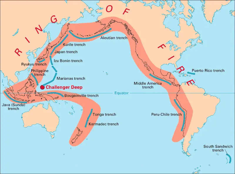
The Ring of Fire is a region around the Pacific Ocean that is known for its high volcanic and seismic activity. The Philippines is part of the Ring of Fire and is one of the most seismically active areas in the world.
Here are some key points about the Philippines and the Ring of Fire:
- Location: The Philippines is located in the western part of the Pacific Ring of Fire, which stretches from New Zealand to Indonesia and up to Japan and the Kamchatka Peninsula in Russia.
- Volcanoes: The Philippines has 22 active volcanoes, with Mount Mayon and Taal Volcano being the most active and well-known. These volcanoes can pose a threat to the safety of nearby residents and can also cause damage to property and infrastructure.
- Earthquakes: The Philippines experiences frequent earthquakes, with an average of around 20 earthquakes of magnitude 5 or higher each year. In 2019, a magnitude 6.1 earthquake hit Luzon, the largest island in the Philippines, causing significant damage and loss of life.
- Effects on society: The high seismic and volcanic activity in the Philippines can have a significant impact on society. Disruptions to transportation and communication can occur, and there can also be damage to infrastructure such as buildings and roads. This can lead to economic losses and can also put people’s lives in danger.
- Preparedness: The Philippine government has taken steps to improve disaster preparedness and response in the face of natural disasters such as earthquakes and volcanic eruptions. This includes the establishment of early warning systems and the development of evacuation plans and disaster response protocols.
Largest Earthquakes
- Luzon earthquake of 1990: On July 16, 1990, a magnitude 7.7 earthquake hit the northern island of Luzon, killing over 1,600 people and causing significant damage to infrastructure.
- Mindanao earthquake of 1976: On August 16, 1976, a magnitude 7.9 earthquake hit the southern island of Mindanao, killing over 5,000 people and causing widespread destruction.
- Bohol earthquake of 2013: On October 15, 2013, a magnitude 7.2 earthquake struck the island of Bohol, killing over 200 people and causing significant damage to buildings and infrastructure.
Largest Volcanic Eruptions
- Pinatubo eruption of 1991: On June 15, 1991, Mount Pinatubo, located in the central island of Luzon, erupted with a VEI (Volcanic Explosivity Index) of 6, making it one of the largest volcanic eruptions of the 20th century. The eruption caused significant damage and displacement of people, with over 700 deaths reported.
- Taal eruption of 1911: On January 30, 1911, Taal Volcano, located in the southern island of Luzon, erupted with a VEI of 4, causing significant damage to nearby towns and villages and resulting in over 1,300 deaths.
- Mayon eruptions: Mount Mayon, located in the southern island of Luzon, has had numerous eruptions throughout history, with the most recent ones occurring in 2009 and 2018. Mayon is known for its steep slopes and symmetrical cone shape, and its eruptions can be particularly dangerous due to the proximity of nearby communities.
History of tsunamis in the Philippines
The Philippines has a long history of tsunamis, which are large ocean waves caused by earthquakes, volcanic eruptions, or other underwater disturbances. Here are some key events in the history of tsunamis in the Philippines:
- 1976 Moro Gulf tsunami: On August 16, 1976, a magnitude 7.9 earthquake hit the southern island of Mindanao, triggering a tsunami that devastated the Moro Gulf region. The tsunami caused over 5,000 deaths and significant damage to coastal communities.
- 1918 Celebes Sea earthquake: On September 6, 1918, a magnitude 8.3 earthquake occurred in the Celebes Sea, which generated a tsunami that affected the eastern coast of Mindanao. The tsunami caused significant damage and loss of life, with over 1000 people reported dead.
- 1867 earthquake and tsunami: On August 16, 1867, a magnitude 7.5 earthquake occurred in the central Visayas region, triggering a tsunami that affected the islands of Samar and Leyte. The tsunami caused significant damage and loss of life, with over 1,000 people reported dead.
- 1646 Sulu Sea earthquake and tsunami: On November 11, 1646, a magnitude 7.5 earthquake occurred in the Sulu Sea, generating a tsunami that affected the southern islands of Mindanao and Sulu. The tsunami caused significant damage and loss of life, with over 500 people reported dead.
- Historical accounts: There are also numerous accounts of tsunamis affecting the Philippines in the past, some of which date back to the 16th century. These events were often linked to earthquakes and volcanic eruptions in the region, and were a significant threat to coastal communities.
The Philippines has a long history of tsunamis, which have caused significant damage and loss of life throughout the country’s history. However, advances in technology and disaster preparedness have helped to reduce the impact of these events in recent years, and ongoing efforts are being made to improve warning systems and evacuation procedures in the event of future tsunamis.
History of Typhoons in the Philippines
The Philippines is one of the countries in the world that is most frequently hit by typhoons, which are tropical cyclones that form in the western Pacific Ocean. Here are some key events in the history of typhoons in the Philippines:
- Typhoon Haiyan (Yolanda): On November 8, 2013, Typhoon Haiyan, one of the strongest storms ever recorded, made landfall in the central Philippines, causing widespread devastation and killing over 6,000 people.
- Typhoon Bopha (Pablo): On December 4, 2012, Typhoon Bopha made landfall in the southern Philippines, causing significant damage and killing over 1,000 people.
- Typhoon Washi (Sendong): On December 16, 2011, Typhoon Washi hit the southern Philippines, causing flash floods and landslides that killed over 1,200 people.
- Typhoon Durian (Reming): On November 30, 2006, Typhoon Durian struck the Bicol region, causing significant damage and killing over 1,200 people.
- Typhoon Haiyan (Ruping): On November 13, 1990, Typhoon Haiyan, also known as Typhoon Ruping, made landfall in the central Philippines, causing significant damage and killing over 700 people.
- Typhoon Nina (Sisang): On November 25, 1987, Typhoon Nina hit the Bicol region, causing significant damage and killing over 1,000 people.
- Typhoon Angela (Rosing): On November 3, 1995, Typhoon Angela, also known as Typhoon Rosing, made landfall in the Bicol region, causing significant damage and killing over 900 people.
In addition to these events, the Philippines experiences an average of 20 typhoons each year, with varying degrees of impact.
Leave a Reply